
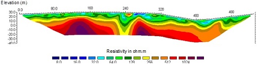
Electrical resistivity tomography is a method based on the measure of apparent resistivity in the subsoil along a linear array of surface electrodes. It provides information about the geometry of subsoil layers and about the presence of anomalies or distinctive structures (faults, clay or sand pockets, fossil thalwegs, altered zones…).
On a practical level, electrodes, between 24 and 128 of them in general, are evenly spaced on a distance of a few tens to a few hundreds of meters. Acquisition in dipole-dipole, pole-dipole or pole-pole mode allows us to reach several tens of meters in depth, depending on the acquisition mode and the distance between the electrodes. 3D processing can also be done provided 3D acquisition is carried out by placing and measuring simultaneously several lines of electrodes. Topography and bathymetry (for underwater profiles) are taken into account during processing..

Apparent resistivity measures are « reversed » (Res2Dinv/Res3Dinv sofwares) to create a cross section of the distribution of the measured resistivities. The limits to the use of electrical resistivity tomography are mainly linked to resistivities and differences of formation resistivity, to the quality of electrode-ground contact, and to the reversal process which sometimes reproduces bias hiding useful information. Boundaries between geological formations have to be controlled and fixed with mechanical boreholes. These allow us to identify the geological characteristics of the formations.